


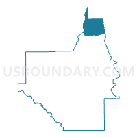
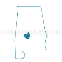
Plantersville VFD, Dallas County, Alabama
About
Outline

Summary
| Unique Area Identifier | 521647 |
| Name | Plantersville VFD |
| County | Dallas County |
| State | Alabama |
| Area (square miles) | 49.01 |
| Land Area (square miles) | 48.81 |
| Water Area (square miles) | 0.20 |
| % of Land Area | 99.60 |
| % of Water Area | 0.40 |
| Latitude of the Internal Point | 32.63067980 |
| Longtitude of the Internal Point | -86.98181520 |
Maps

Graphs
Select a template below for downloading or customizing gragh for Plantersville VFD, Dallas County, Alabama


Neighbors
Neighoring Voting District (by Name) Neighboring Voting District on the Map
- Jones Community Center, Autauga County, AL
- Ocmulgee Fire Station, Perry County, AL
- Pinetucky, Perry County, AL
- So. Chilton Fire Station, Chilton County, AL
- Summerfield VFD, Dallas County, AL
- Valley Grande VFD, Dallas County, AL
Top 10 Neighboring County Subdivision (by Population) Neighboring County Subdivision on the Map
- Selma CCD, Dallas County, AL (32,439)
- Maplesville CCD, Chilton County, AL (2,902)
- Billingsley CCD, Autauga County, AL (2,894)
- Sprott CCD, Perry County, AL (1,055)
Top 10 Neighboring Unified School District (by Population) Neighboring Unified School District on the Map
- Autauga County School District, AL (54,571)
- Chilton County School District, AL (43,643)
- Dallas County School District, AL (23,064)
- Perry County School District, AL (10,591)
Top 10 Neighboring State Legislative District Lower Chamber (by Population) Neighboring State Legislative District Lower Chamber on the Map
- State House District 42, AL (48,338)
- State House District 72, AL (39,414)
- State House District 67, AL (37,878)
- State House District 69, AL (37,572)
Top 10 Neighboring State Legislative District Upper Chamber (by Population) Neighboring State Legislative District Upper Chamber on the Map
- State Senate District 14, AL (168,669)
- State Senate District 24, AL (118,832)
- State Senate District 23, AL (111,939)
Top 10 Neighboring 111th Congressional District (by Population) Neighboring 111th Congressional District on the Map
- Congressional District 6, AL (754,482)
- Congressional District 2, AL (673,877)
- Congressional District 7, AL (603,352)
Top 10 Neighboring Census Tract (by Population) Neighboring Census Tract on the Map
- Census Tract 9561, Dallas County, AL (6,753)
- Census Tract 605, Chilton County, AL (2,902)
- Census Tract 210, Autauga County, AL (2,894)
- Census Tract 9562.02, Dallas County, AL (2,327)
- Census Tract 6868, Perry County, AL (1,055)